Atmospheric Rivers
| Definition | A long, narrow corridor of concentrated water vapor transport in the atmosphere. |
|---|---|
| Primary hazard | Extreme precipitation, often leading to flooding and landslides. |
| Typical length | Several thousand kilometers. |
| Typical width | Several hundred kilometers. |
| Water vapor source | Typically the tropical or subtropical Pacific Ocean. |
| Commonly affected regions | West coasts of continents, notably western North America. |
| Warning type | Atmospheric River (AR) scale (AR1-AR5), based on intensity and duration. |
| Original use of term | Coined in scientific literature in the early 1990s. |
Origin and history
The term "atmospheric river" was first coined by researchers in the late 20th century, with its conceptual foundations emerging from meteorological studies in the 1970s and 1980s. The phenomenon itself, however, is a natural and ancient feature of Earth's global climate system, not a modern creation. Scientific documentation and understanding accelerated significantly in the 1990s as satellite data and improved weather models allowed for better tracking and analysis. The formalization of the term is widely attributed to scientists Reginald Newell and Yong Zhu of the Massachusetts Institute of Technology in the early 1990s. Their work identified these structures as the primary transporters of water vapor from the tropics toward the poles. The concept has since become a cornerstone of mid-latitude and coastal meteorology, particularly for understanding extreme precipitation events.
What it is for
Atmospheric rivers serve a critical function in the global hydrological cycle by redistributing vast quantities of water vapor from equatorial regions toward the poles. They are responsible for a significant percentage of the total meridional (north-south) transport of water vapor in the mid-latitudes. This transport is essential for replenishing freshwater supplies in many regions through rainfall and snowpack accumulation. In ecosystems, these events drive necessary water pulses that sustain rivers, forests, and agricultural zones dependent on seasonal precipitation. From a climatological perspective, they act as key mechanisms for moving heat energy from the tropics, thereby influencing broader weather patterns. Their function is fundamentally one of large-scale planetary water and energy balance, making them integral to regional climates.
Overview
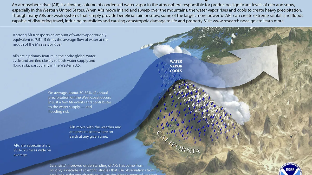
An atmospheric river is a long, narrow, and transient corridor of concentrated moisture in the lower atmosphere, often thousands of kilometers long but only a few hundred wide. It is akin to a river in the sky, carrying water vapor amounts comparable to the flow at the mouth of a major terrestrial river. These features are typically associated with the warm conveyor belt of extratropical cyclones, forming in the warm sector ahead of cold fronts. When an atmospheric river makes landfall and is forced upward by mountain ranges, it can produce intense, prolonged rainfall or heavy snowfall, known as orographic enhancement. The intensity of such an event is often categorized on a scale from AR-1 (weak) to AR-5 (exceptional) based on its duration and peak water vapor transport. Not all atmospheric rivers cause damage; many are weak or moderate systems that provide beneficial rain and snow.
What to know
It is crucial to understand that an atmospheric river is not a storm itself, but a moisture plume that fuels storms, with its impacts entirely dependent on where and how it interacts with topography. The most extreme rainfall and flood risks occur when these moisture plumes stall against mountain ranges, releasing their water vapor over a confined area for an extended period. A key warning sign for meteorologists is the development of a strong, persistent low-level jet stream transporting tropical moisture directly toward a coastline. Preparedness should focus on the potential for both flooding hazards and secondary risks like landslides and debris flows in steep terrain. While the West Coasts of continents, like North America and Europe, are most famous for these events, they occur globally, including over the Southern Ocean and East Asia. Official warnings will focus on the expected precipitation totals, flood watches, and high wind advisories triggered by the associated weather systems.
Common questions
A common question is whether climate change is affecting atmospheric rivers, and research indicates a trend toward increased frequency of the most intense (AR-4 and AR-5) categories as a warmer atmosphere holds more moisture. People often ask if every atmospheric river causes catastrophic flooding, and the answer is no, as many are benign or beneficial, with only a small percentage leading to major damage. Many wonder how long these events last, and while the moisture plume can persist for days, the most intense precipitation at a single location typically occurs over a period of 24 to 48 hours. A frequent point of confusion is the difference between an atmospheric river and a "Pineapple Express," which is a specific subtype that transports moisture from the tropical Pacific near Hawaii to the West Coast of North America. Individuals often question if they can be predicted, and while their development can be forecast several days in advance, precise rainfall totals and locations remain challenging due to topographic complexities. Finally, people ask about safety, and the primary advice is to heed official warnings for flooding and landslides, avoid driving through flooded roadways, and prepare for potential power outages.
Pros and cons
The primary benefit of atmospheric rivers is their role as a vital water source, contributing 30-50% of annual precipitation on some coastlines and critically rebuilding snowpack and reservoir supplies, which is essential for water security and agriculture. A significant con is their capacity to cause extreme, rapid-onset flooding, often overwhelming drainage systems and leading to widespread property damage, infrastructure failure, and loss of life. A common mistake by residents in vulnerable areas is underestimating the cumulative impact of prolonged, moderate rainfall, focusing only on short-duration downpours, which can lead to a lack of preparedness for rising rivers and saturated ground. Those who often regret the impacts are communities in floodplains or at the base of steep, fire-scarred slopes, where the same storm can trigger devastating debris flows. Another drawback is the "feast or famine" dynamic they can create in regional water supplies, with intense deluges that are difficult to capture fully, followed by long dry periods. The binary nature of their impact, being either desperately needed or destructively excessive, makes water resource management and public communication particularly challenging.
Who it suits
This meteorological phenomenon primarily concerns residents and emergency managers in coastal and mountainous regions, particularly along the west coasts of continents like North and South America, Europe, and New Zealand. It is a critical concept for water resource planners, hydrologists, and agriculturalists in these regions, who must balance flood risk with water supply needs from these events. Climate scientists and meteorologists specializing in extreme precipitation and global water vapor transport study atmospheric rivers as a core component of the climate system. Infrastructure engineers, particularly those designing dams, culverts, and flood control systems, must account for the intense rainfall rates associated with these events. Homeowners and property developers in known atmospheric river pathways need to understand the associated flood and landslide risks for informed land-use and insurance decisions. Finally, it suits any individual seeking to understand the major drivers of both water security and natural hazard risk in mid-latitude coastal ecosystems.